- Mt. Canobolas & Lake Canobolas
- Rain & Floods
- Object :: Pluviometer
- Object :: Tipping Bucket
- Object :: Rainfall Records
- Introducing Water in Orange
- Object :: Douglas Pump
- Spiritual Dimensions
- Interview :: Ian Marr
- Object :: Ian Marr Bench
- Interview :: Carl MacKander
- Object :: Baptismal Font
- Object :: Chalices
- Interview :: Mandy Martin
- Wiradjuri People
- Interview :: Joyce Williams
- Object :: Painting by Joanne Reid
- Canowindra Fish Fossils
- Object :: Fossils
- Swamps & Wetlands
- Interview :: Rodney Tonkin
- Interview :: Jill Campbell
- Object :: Willow
Rain and Floods
Orange has a relatively high average annual rainfall with winter being the wettest period and summer and autumn the driest. Snowfalls are also experienced between May and September. Snow does not settle on the ground for long, though it does accumulate in sheltered pockets on Mount Canobolas particularly on the southern slopes, for weeks at a time.
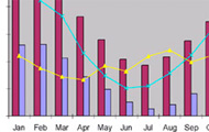
Rain chart
Orange City Council has seven automatic rain gauges located throughout the local government area that not only measure how much rain has fallen but also how quickly it falls. From this information engineers can develop models of creek and channel flows to improve public safety and limit damage to property. Some other physical measures that have been put in place include detention basins that trap floodwaters in large storms. Three rain gauges have been installed near the main water supply dams that report information back to Council and the State Emergency Service. This 'real-time' information is used to ensure the safety of downstream residents in the unlikely event of an extreme flood that could damage the wall of Suma Park Dam.
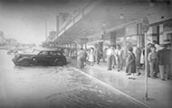
Blackman's Swamp Creek and its tributary, the East Orange Channel, have been known to break their banks since the earliest days of white settlement. While generally of a short duration and relatively minor these floods do have a significant impact on the community in terms of costs through property damage and inconvenience. The rapid nature of flooding particularly in rural areas can present a particular hazard for the unwary and on some occasions result in loss of life.

View Caption